Asia
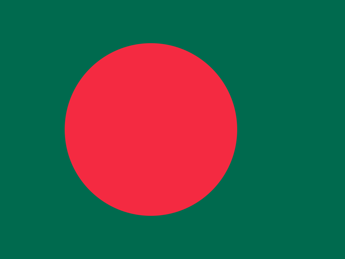
Bangladesh Flag
Bangladesh is a densely populated country in South Asia, shaped by great rivers, fertile plains and a rich Bengali cultural tradition. Its green flag and offset red disc carry powerful associations with the land, the rising sun and the struggle for independence.
Capital
Dhaka
Continent
Asia
Population
169.0 million
Development indicators
GDP per capita
$2,550
USD per year (approx. 2023)
Human Development Index
0.670
Medium development
World Bank income classification
Lower-Middle Income (LMIC)
LMIC
🌡️ Climate: Tropical / Subtropical
Flag symbolism
Green represents the lushness of the land and Islam. The red disc represents the rising sun and the blood shed during the independence war.
circlesun
Did you know?
Bangladesh is home to the Sundarbans — the world's largest mangrove forest.
Test your knowledge
Think you know your world flags? Try the FlagAtlas daily challenge, speed quiz, or explore all Asia flags.
📚 Revising for GCSE Geography? Visit our free revision page →
About Bangladesh
Bangladesh is a country in South Asia, almost entirely surrounded by India except for borders with Myanmar and a coastline on the Bay of Bengal. It is one of the world's most densely populated countries.
Dhaka is the capital and largest city. Bangladesh is a parliamentary republic whose society and culture are strongly shaped by the Bengali language, literature, music, religion and the great river systems that cross the country.
CapitalDhaka
RegionSouth Asia
PopulationAbout 170m
Area148,460 km²
CurrencyBangladeshi taka
Official languageBengali
The flag of Bangladesh
The national flag has a dark green field with a red disc positioned slightly towards the hoist. The design is simple, but its colours carry strong national symbolism.
The red disc is deliberately not centred.
It is shifted slightly towards the flagpole so that it appears visually centred when the flag is flying. The green field represents the lush landscape of Bangladesh, while the red disc is associated with the rising sun and the sacrifices of the independence struggle.
The present flag was adopted on 17 January 1972, shortly after Bangladesh became independent.
What do the colours on Bangladesh's flag mean?
Green is associated with the lushness of Bangladesh's landscape and is also connected with the country's Islamic cultural heritage. Red represents the rising sun and is traditionally linked with the blood shed during the Liberation War.
The combination makes the flag both a geographical and historical symbol: green evokes the land, while red recalls the country's emergence as an independent nation.
Why is the red circle off-centre?
The red disc is placed slightly towards the hoist rather than exactly in the middle of the flag. This helps it appear optically centred when the flag is hanging or flying.
The red disc can also be interpreted visually as the rising sun over the green landscape of Bangladesh, giving the design a strong sense of movement and renewal.
A short history of Bangladesh
The Bengal region has a long history of kingdoms, trade, literature and cultural exchange. It later became part of the Mughal Empire and, from the eighteenth century, came increasingly under British rule.
In 1947 British India was partitioned. Bengal was divided, with the eastern part becoming East Bengal and later East Pakistan, while West Bengal became part of India.
Political, linguistic and economic tensions grew between East and West Pakistan. The Bengali Language Movement of 1952 became a powerful expression of East Pakistani identity, while demands for greater autonomy intensified over the following decades.
After a devastating conflict in 1971, Bangladesh achieved independence. The new country adopted its green and red national flag in 1972.
Bangladesh's flag history
The current flag grew out of the independence movement and was designed to express a distinct Bengali national identity.
1947 — PartitionEast Bengal became part of Pakistan as East Bengal, later renamed East Pakistan.
1952 — Language MovementProtests over the status of Bengali became an important part of the development of Bengali national identity.
1971 — Liberation WarBangladesh fought for independence from Pakistan after escalating political conflict and military repression.
1972 — national flagThe green and red flag was formally adopted after independence.
1972 — design simplifiedThe original independence-era flag included a map of Bangladesh inside the red disc; the map was removed from the official design.
TodayThe green-and-red flag is one of the strongest symbols of Bangladesh's independence and identity.
The Liberation War of 1971
Bangladesh's independence followed a major political and military conflict in 1971. The struggle began after long-running disputes over political representation, economic inequality and the status of Bengali identity.
The conflict caused enormous loss of life and displacement. Bangladesh emerged as an independent country in December 1971, and the events of that year remain central to national identity.
Geography of Bangladesh
Bangladesh lies mainly on the vast delta formed by the Ganges, Brahmaputra and Meghna river systems. Much of the country is low-lying and extremely fertile, although this geography also makes many areas vulnerable to flooding and cyclones.
Bangladesh's neighbours
Bangladesh shares most of its land borders with India and also has a border with Myanmar. The Bay of Bengal forms its southern coastline.
The country's rivers are vital for farming, transport, fishing and daily life.
The Sundarbans
The Sundarbans is the world's largest contiguous mangrove forest and stretches across Bangladesh and neighbouring India. The Bangladeshi part occupies a large area of the country's south-west.
It is famous for its Bengal tigers, mangrove forests and complex network of tidal waterways. The forest also acts as an important natural barrier against storms and coastal flooding.
Rivers and flooding
Bangladesh is one of the world's great river countries. The Ganges, Brahmaputra and Meghna systems bring enormous quantities of water and sediment into the delta.
Flooding can be destructive, but seasonal water also supports agriculture and replenishes fertile soils. Climate change and sea-level rise create additional challenges for low-lying coastal communities.
People, language and culture
Bengali, or Bangla, is the official language and is central to Bangladesh's national identity. Bengali literature, poetry, music and theatre have a particularly strong cultural tradition.
Bangladeshi culture includes a rich tradition of folk music, classical and popular Bengali music, textiles, food and festivals. The country is predominantly Muslim, with Hindu and other religious communities also contributing to its cultural life.
The Bengali Language Movement
The Language Movement of 1952 was a major turning point in Bengali national consciousness. Students and activists protested against attempts to make Urdu the sole state language of Pakistan.
The movement ultimately helped secure recognition for Bengali and became an enduring symbol of linguistic and cultural rights. International Mother Language Day is observed on 21 February in memory of those events.
Bangladesh's economy
Bangladesh has experienced substantial economic development in recent decades. The garment and textile industry is particularly important and makes the country one of the world's major clothing manufacturing centres.
Agriculture remains important, while services, remittances from overseas workers, manufacturing and expanding urban industries also contribute to the economy.
Dhaka
Dhaka is Bangladesh's capital and one of the world's largest and most densely populated urban areas. It is the country's political, commercial, educational and cultural centre.
The city has grown rapidly, with modern business districts existing alongside historic neighbourhoods, markets, mosques and riverside communities.
Bangladesh and climate change
Bangladesh is particularly exposed to climate-related risks because much of its territory is low-lying and close to major rivers and the coast.
Cyclones, storm surges, river flooding and salinity affect vulnerable communities. At the same time, Bangladesh has developed significant experience in cyclone preparedness and community-based disaster response.
Bangladesh today
Modern Bangladesh is a sovereign republic with Bengali language and culture at the heart of its national identity. The country's large population, expanding economy and strategic position in South Asia make it an increasingly important regional state.
The green-and-red flag remains closely associated with the independence struggle and the country's continuing national story.
Why is Bangladesh's flag so simple?
The flag uses only two main colours and one geometric shape. This makes it easy to recognise and reproduce while allowing the symbolism to remain strong.
It is a good example of how a national flag can communicate history and identity without using a detailed coat of arms or complicated emblem.
Explore Bangladesh on FlagAtlas
Continue exploring Bangladesh and the world's flags with these FlagAtlas resources.