Africa
Cape Verde Flag
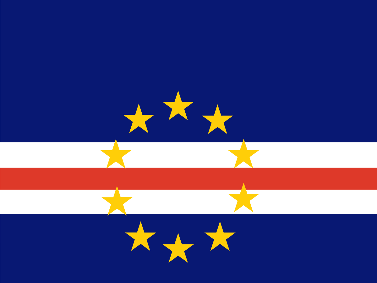
Cabo Verde, also known as Cape Verde, is an island country in the Atlantic Ocean off the coast of West Africa. Its striking flag uses deep blue, white and red bands with ten golden stars representing the country's main islands. The islands are volcanic, culturally distinctive and closely connected to the sea.
Capital
Praia
Continent
Africa
Population
560 thousand
Development indicators
GDP per capita
$3,900
USD per year (approx. 2023)
Human Development Index
0.651
Medium development
World Bank income classification
Lower-Middle Income (LMIC)
LMIC
🌡️ Climate: Tropical / Semi-arid
Flag symbolism
Blue represents the Atlantic Ocean and sky. White represents peace and red represents effort and the determination involved in building the nation. The ten golden stars represent the ten main islands.
starscircle
Did you know?
Cape Verde is so volcanic that its highest peak, Pico do Fogo, is still an active volcano.
Test your knowledge
Think you know your world flags? Try the FlagAtlas daily challenge, speed quiz, or explore all Africa flags.
📚 Revising for GCSE Geography? Visit our free revision page →
About Cabo Verde
Cabo Verde is an island country made up of ten main islands and several smaller islets in the Atlantic Ocean, roughly 570 kilometres west of Senegal. The islands are divided into the Barlavento and Sotavento groups.
Praia, on Santiago Island, is the capital and largest political centre. Cabo Verde is known for its volcanic landscapes, dry climate, Atlantic beaches, distinctive Creole culture and strong links with the wider Portuguese-speaking world.
CapitalPraia
RegionWest Africa
PopulationAbout 520,000
Area4,033 km²
CurrencyCabo Verdean escudo
Official languagePortuguese
The flag of Cabo Verde
The national flag has a large blue field crossed by three horizontal stripes: white, red and white. Ten yellow five-pointed stars form a circle near the hoist.
The ten stars represent the ten main islands.
The stars are arranged in a circle rather than simply placed in a straight line, giving the flag its distinctive appearance.
The present flag was adopted in 1992 as part of the country's transition to a multi-party political system.
What do the colours on Cabo Verde's flag mean?
Blue represents the sea and sky surrounding the islands. White represents peace, while red represents effort and the determination involved in building the country.
The design reflects Cabo Verde's identity as an Atlantic island nation rather than using a conventional continental African flag pattern.
What do the ten stars mean?
The ten yellow stars represent the ten main islands of Cabo Verde. They are arranged in a circle, symbolising the unity of the islands that make up the country.
The ten islands are Santiago, Santo Antão, São Vicente, São Nicolau, Sal, Boa Vista, Maio, Fogo, Brava and Santa Luzia. Santa Luzia is uninhabited but is counted among the main islands.
Why are the stars arranged in a circle?
The circle gives the flag a strong visual representation of unity. Rather than placing the islands in a geographical outline, the design brings the ten stars together as a single national symbol.
The arrangement also helps distinguish the Cabo Verde flag from other blue, white and red national flags.
A short history of Cabo Verde
The islands were uninhabited when Portuguese explorers reached them in the fifteenth century. Portugal established settlements and Cabo Verde became an important centre in the Atlantic trade network.
The islands later became an important stopping point for ships travelling between Europe, Africa and the Americas. The history of Cabo Verde is therefore closely connected with the wider history of the Atlantic world and the transatlantic slave trade.
Cabo Verde became independent from Portugal on 5 July 1975. It initially formed a political union with Guinea-Bissau under the PAIGC before becoming a separate state.
In 1991, the country held multi-party elections. The present flag was adopted in 1992 and replaced the earlier Pan-African-inspired flag.
Cabo Verde's flag history
The change from the earlier flag to the current design reflected a significant change in the country's political identity.
1460s — Portuguese settlementPortuguese settlers established communities on the previously uninhabited islands.
1490s onwards — Atlantic tradeCabo Verde became an important Atlantic trading and maritime centre.
1950s–1970s — independence movementThe independence struggle developed alongside the wider anti-colonial movement in Portuguese Africa.
1975 — independenceCabo Verde became independent from Portugal.
1991 — multi-party democracyThe first democratic change of government through multi-party elections took place.
1992 — current flagThe blue, white, red and ten-star flag was adopted.
TodayThe flag remains a symbol of island unity and Cabo Verde's Atlantic identity.
The old flag of Cabo Verde
After independence in 1975, Cabo Verde used a flag with red, yellow and green horizontal bands and a vertical red panel containing symbols associated with the ruling independence movement.
The design was closely related to the flag of Guinea-Bissau because both countries emerged from the same anti-colonial political movement. Cabo Verde adopted its current, more distinctive design in 1992.
Praia — the capital
Praia is located on Santiago, the largest and most populous island. It is the political, administrative and economic centre of Cabo Verde.
The historic Plateau district contains government buildings, churches, squares and other reminders of the city's Portuguese colonial heritage.
Volcanoes and Pico do Fogo
Cabo Verde is volcanic in origin. The islands were built by volcanic activity on the Atlantic Ocean floor and many retain dramatic volcanic landscapes.
Pico do Fogo, on Fogo Island, is the country's highest point at 2,829 metres. It is an active volcano and has erupted several times in recorded history.
Fogo and the volcanic landscape
The interior of Fogo is dominated by the large volcanic caldera of Chã das Caldeiras. Communities have traditionally farmed fertile volcanic soils inside the caldera despite the risk of eruptions.
Coffee, grapes and other crops are cultivated in parts of the volcanic landscape, creating agricultural traditions that are unusual for such a dry island country.
Cabo Verde's dry climate
Cabo Verde has a generally dry climate because the islands lie in the tropical Atlantic near the Sahel. Rainfall is highly seasonal and varies significantly from island to island.
Water scarcity has historically been one of the country's biggest environmental challenges. Modern infrastructure, desalination and careful water management are increasingly important.
Sea, beaches and tourism
Tourism is one of the most important parts of Cabo Verde's modern economy. Islands such as Sal and Boa Vista are known for sandy beaches, clear water and watersports.
The islands also offer very different experiences: mountainous Santo Antão is famous for hiking, while Fogo is known for volcanic scenery and Santiago for history and culture.
Cabo Verdean culture
Cabo Verde has a distinctive Creole culture created through centuries of interaction between African and Portuguese influences. The majority of people are of mixed African and European ancestry.
Cape Verdean Creole, known locally as Kriolu, is widely spoken alongside Portuguese. Different islands have their own varieties of Creole.
Music — morna and Cesária Évora
Morna is one of Cabo Verde's best-known musical traditions. It is often associated with themes of longing, love, separation and life at sea.
The singer Cesária Évora became the country's most famous international musical ambassador. Her recordings helped bring Cape Verdean music to audiences around the world.
Migration and the Cabo Verdean diaspora
Cabo Verde has a large diaspora, with many people of Cabo Verdean origin living in countries including Portugal, the United States, France and the Netherlands.
Remittances from people living abroad are important to the economy and help maintain strong family and cultural connections between the islands and communities overseas.
Cabo Verde today
Cabo Verde is a stable multi-party democracy and is often regarded as one of Africa's stronger examples of democratic governance. The economy depends heavily on services, tourism, remittances and overseas links.
The country faces challenges including water scarcity, dependence on imports, exposure to climate change and the limited natural resources of its small islands.
Why is Cabo Verde's flag interesting?
Cabo Verde's flag tells a story of an island nation rather than relying on a traditional African land-based design. The blue field dominates because the Atlantic Ocean is fundamental to the country's geography and history.
The ten stars then turn the country's geography into a national symbol, while the change from the post-independence flag to the current design reflects Cabo Verde's political development.
Explore Cabo Verde on FlagAtlas
Continue exploring Cabo Verde and the world's flags with these FlagAtlas resources.