About Djibouti
Djibouti is a small country in the Horn of Africa, positioned beside the Red Sea and the Gulf of Aden. Its location gives it major strategic importance because ships travelling between the Indian Ocean and the Mediterranean pass through nearby waters.
Djibouti City is the capital and largest urban centre. The country is known for its extremely dry climate, volcanic landscapes, salt lakes, coral reefs and important international port facilities.
CapitalDjibouti City
RegionHorn of Africa
PopulationAbout 1 million
CurrencyDjiboutian franc
Official languagesFrench & Arabic
Lowest pointLake Assal
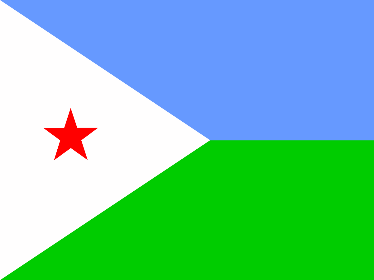
The flag of Djibouti
The Djibouti flag has two horizontal fields: light blue above green. A white triangle extends from the hoist and contains a red five-pointed star.
The flag combines national, ethnic and political symbolism.
The blue and green colours are associated with the country's two largest communities as well as the sky and land, while the white triangle represents peace.
The red star represents unity and the struggle for independence.
What do the colours mean?
The light blue is associated with the sky and sea and with the Issa Somali community. The green represents the land and is associated with the Afar community.
The white triangle represents peace. The red star represents unity and the sacrifices associated with the country's independence struggle.
The red star
The red five-pointed star is one of the most important symbols on the Djibouti flag. It represents unity and is linked to the country's national identity.
The star also reflects the idea of bringing the country's different communities together within a single independent state.
A short history of Djibouti
The territory that is now Djibouti has long been connected to Red Sea trade routes. Its position made it important to merchants travelling between Africa, Arabia and the wider Indian Ocean.
France established control over the area during the nineteenth century. It became known as French Somaliland and later as the French Territory of the Afars and Issas.
Djibouti achieved independence on 27 June 1977. The new republic adopted its current national flag.
Flag history timeline
Ancient trade routesThe region developed around important trading networks linking the Red Sea, Arabia and East Africa.
1860s–1880s — French expansionFrance established a colonial presence around the Gulf of Tadjoura and later expanded its control.
1896 — French SomalilandThe territory became a French colony and developed around the port of Djibouti.
1967 — Territory of the Afars and IssasThe colonial territory was renamed as its path towards self-government continued.
1977 — independenceDjibouti became independent from France on 27 June.
TodayThe blue, green, white and red flag remains the national flag of Djibouti.
Djibouti City
Djibouti City is the capital, largest city and main economic centre. It developed around a natural harbour and became the focus of the country's modern transport and trading network.
The city sits close to the entrance to the Gulf of Aden and has an important port, railway connections and road links to neighbouring Ethiopia.
The strategic location
Djibouti lies beside the Bab el-Mandeb Strait, one of the world's most important maritime chokepoints. The strait connects the Red Sea with the Gulf of Aden and Indian Ocean.
This location has made Djibouti strategically important for international shipping and military operations. Several countries maintain military facilities or bases in the country.
Djibouti's ports
Djibouti's economy is strongly connected to its ports. The country's facilities handle cargo serving both Djibouti and neighbouring Ethiopia, a large landlocked country to the west.
Modern port infrastructure has made Djibouti an important logistics and trans-shipment centre in the Horn of Africa.
Lake Assal
Lake Assal is a volcanic crater lake in central Djibouti and lies roughly 155 metres below sea level. It is the lowest point in Africa.
The lake is extremely salty because intense evaporation concentrates minerals in its waters. Its white salt deposits contrast sharply with the surrounding dark volcanic landscape.
Lake Abbé
Lake Abbé lies on the border between Djibouti and Ethiopia. It is famous for dramatic limestone chimneys created by mineral-rich hot springs.
The unusual landscape has been compared with an alien world and was used as a filming location for the science-fiction film Planet of the Apes.
The Gulf of Tadjoura
The Gulf of Tadjoura cuts deeply into Djibouti from the Gulf of Aden. Its sheltered waters contain coral reefs, islands and important marine habitats.
The gulf is also connected to the country's fishing, tourism and maritime traditions and has been important to settlements for centuries.
Djibouti's wildlife
Despite its harsh climate, Djibouti supports a variety of wildlife. Marine ecosystems include coral reefs, fish, dolphins and other species, while terrestrial areas contain desert-adapted animals.
The country is also associated with migratory birds because of its position between Africa, Arabia and Asia.
Whale sharks
The waters around Djibouti are known for seasonal gatherings of whale sharks, the world's largest fish. These enormous but generally gentle animals feed on plankton.
Marine tourism has developed around opportunities to observe whale sharks and other wildlife in the Gulf of Tadjoura and nearby waters.
Climate
Djibouti has one of the hottest and driest climates in the world. Temperatures can become extremely high, particularly during the summer months, while rainfall is limited and irregular.
Coastal areas are hot and humid, whereas inland desert and volcanic regions can be even more extreme. Water scarcity is an important environmental challenge.
The Afar people
The Afar are one of the major ethnic groups associated with Djibouti. Afar communities also live across neighbouring parts of Ethiopia and Eritrea.
Afar culture has traditionally been linked to pastoralism, trade and life in one of the world's harshest environments.
The Issa Somali community
The Issa are a Somali clan group with a major presence in Djibouti. Somali is widely spoken in the country alongside French and Arabic.
The country's flag deliberately includes symbolism associated with both the Issa and Afar communities, reflecting the importance of national unity.
Languages of Djibouti
French and Arabic are the official languages of Djibouti. Somali and Afar are also widely spoken and are important community languages.
The country's language mix reflects its location between Africa and Arabia and its history as a former French territory.
Djibouti and Ethiopia
Djibouti has particularly close economic links with Ethiopia. Because Ethiopia is landlocked, Djibouti's ports provide one of its main routes to international markets.
Roads and railways connect Djibouti with Ethiopia, making transport and logistics central to the two countries' relationship.
Djibouti and the wider Horn of Africa
Djibouti is surrounded by Ethiopia, Eritrea and Somalia and lies close to Yemen across the Gulf of Aden. Its position places it at the meeting point of several important African and Middle Eastern regions.
This geography gives the country significance far beyond its small size and helps explain the large international presence in Djibouti.
Independence and national identity
Djibouti became independent from France in 1977. The flag adopted by the new republic reflected the country's communities, geography and hopes for unity.
The combination of blue, green, white and red creates a flag that is both visually distinctive and closely connected to the country's national story.
Djibouti today
Djibouti is a republic whose economy is dominated by services, transport, logistics and port activity. Its strategic location has also made it an important centre for international military and security cooperation.
The country faces significant challenges including water scarcity, unemployment, poverty and the effects of a harsh climate, while its ports and location provide major opportunities for economic development.
Why is Djibouti's flag interesting?
Djibouti's flag is a good example of how a national flag can combine geography with the identities of different communities. The blue and green fields, white triangle and red star each contribute to the story of the country.
It is also a useful flag to study alongside the flags of Somalia and other countries in the Horn of Africa because of the region's shared history, languages and communities.
Explore Djibouti on FlagAtlas
Continue exploring Djibouti and the world's flags with these FlagAtlas resources.