About Kiribati
Kiribati is a Pacific island country made up of 33 islands, including low-lying coral atolls spread across a huge area of ocean. South Tarawa is the capital and the country's main population centre.
Kiribati is especially notable for its enormous ocean territory, traditional island culture and vulnerability to sea-level rise.
CapitalSouth Tarawa
RegionMicronesia / Oceania
PopulationAbout 120,000
CurrencyAustralian dollar
LanguagesGilbertese & English
Independence12 July 1979
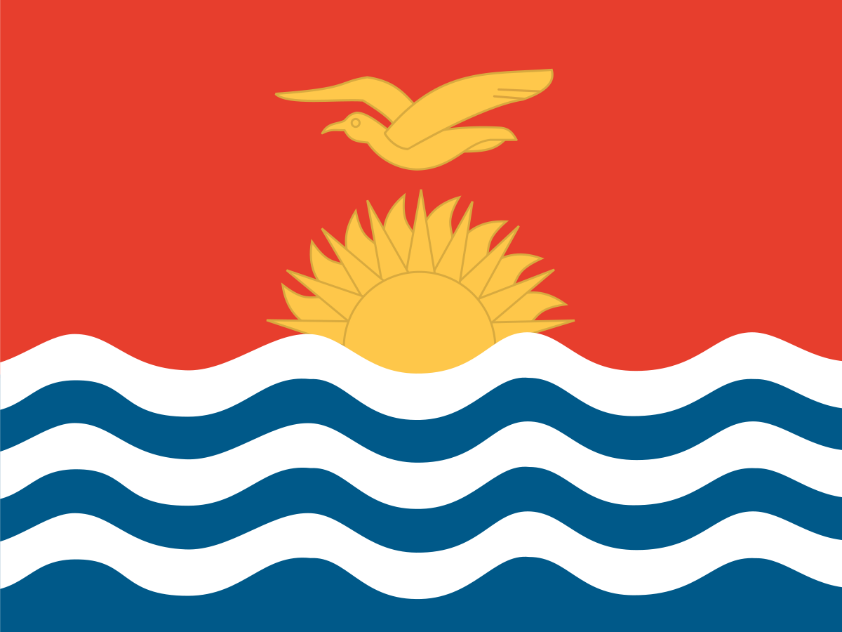
The flag of Kiribati
Kiribati's national flag is divided into a red upper section and a lower section of blue and white waves. A golden rising sun and golden frigate bird dominate the upper half.
The flag is almost a miniature map of Kiribati's identity.
The blue and white waves represent the Pacific Ocean, the rising sun reflects Kiribati's position near the International Date Line and the frigate bird symbolises freedom and the country's connection with the sea and islands.
The design is based on the colonial-era coat of arms created for the Gilbert and Ellice Islands and became the national flag when Kiribati gained independence in 1979.
What do the colours mean?
The flag combines red, blue, white and yellow. Red forms the sky-like upper field, while blue and white create waves beneath it.
The blue and white bands represent the Pacific Ocean. Yellow is used for the sun and frigate bird, while the overall design reflects Kiribati's island environment.
The red field
The large red upper field provides the background for the rising sun and frigate bird. It comes from the heraldic design associated with the Gilbert and Ellice Islands.
The red field makes the golden symbols particularly prominent.
The blue and white waves
The alternating blue and white waves represent the Pacific Ocean surrounding Kiribati.
They also visually emphasise that Kiribati is a nation made up of tiny islands scattered across an enormous area of ocean.
The rising sun
The golden rising sun represents the sun over the Pacific and is associated with Kiribati's position close to the International Date Line.
The sun has 17 rays, traditionally representing the 16 Gilbert Islands and Banaba.
The frigate bird
The golden frigate bird is one of the flag's most distinctive symbols. Frigate birds are seabirds strongly associated with tropical Pacific islands.
The bird's flight is commonly interpreted as representing freedom, power and the relationship between the people of Kiribati and the ocean.
The 17 rays
The rising sun has 17 rays. These traditionally represent the 16 Gilbert Islands and Banaba.
The detail connects the flag directly to the geography and historical identity of the country.
A short history of Kiribati
Kiribati's islands were settled by Austronesian peoples many centuries ago. The islands later became connected to European exploration, missionary activity and British colonial administration.
The Gilbert Islands and Ellice Islands were administered together by Britain before eventually separating into Kiribati and Tuvalu.
History timeline
Ancient settlement — Austronesian peoplesMicronesian and Austronesian peoples settled the islands centuries before European contact, developing distinctive maritime societies.
European explorationEuropean navigators began charting the central Pacific islands from the sixteenth century onward.
19th century — Missionaries and tradersChristian missionaries and commercial interests became increasingly influential across the Gilbert Islands.
1892 — British protectorateBritain declared the Gilbert Islands a protectorate.
1916 — Gilbert and Ellice Islands ColonyThe Gilbert Islands and Ellice Islands were combined into a British colony.
1942–43 — Japanese occupationJapanese forces occupied parts of the Gilbert Islands during the Second World War.
1943 — Battle of TarawaUS forces fought Japanese troops at Tarawa in one of the Pacific War's major amphibious battles.
1960s–70s — Political self-governmentKiribati moved gradually towards greater internal self-government as British colonial rule weakened.
1975 — Ellice Islands separateThe Ellice Islands separated from the colony and later became Tuvalu.
1979 — IndependenceThe Gilbert Islands became the independent Republic of Kiribati on 12 July 1979.
1995 — Date Line adjustmentKiribati moved the International Date Line around its eastern islands so the country could share the same calendar date.
2000s–present — Climate changeSea-level rise, coastal erosion, saltwater intrusion and freshwater security have become major national concerns.
TodayKiribati remains one of the world's most geographically dispersed and climate-vulnerable island states.
Traditional island life
Traditional Kiribati society developed around fishing, coconut cultivation, navigation and life on narrow coral atolls.
Community life has historically centred on villages, meeting houses and strong family networks.
The Gilbert Islands
The Gilbert Islands form the central group of islands that gave modern Kiribati much of its territory and identity.
Most of the country's population lives in this island group, including the heavily populated Tarawa atoll.
Banaba
Banaba is a raised coral island that is geographically separate from the Gilbert atolls. It was once one of the world's major sources of phosphate.
Extensive phosphate mining dramatically altered the island's landscape and led to the relocation of many Banabans.
Phosphate mining
Phosphate mining on Banaba became economically important during the colonial period. Mining removed much of the island's surface and had profound environmental and social consequences.
Banaba's story is an important part of Kiribati's colonial history.
The Ellice Islands and Tuvalu
The British colony of the Gilbert and Ellice Islands included two culturally and geographically distinct island groups. The Ellice Islands separated in 1975 and became the independent country of Tuvalu in 1978.
The Gilbert Islands became Kiribati in 1979.
The Battle of Tarawa
The Battle of Tarawa in November 1943 was a major US assault on Japanese-held Betio in the Tarawa atoll. Heavy fighting caused very high casualties on both sides.
The battle demonstrated the difficulty of amphibious warfare against strongly defended Pacific islands.
Kiribati and the International Date Line
Kiribati is unusual because its islands extend across a huge area of the central Pacific. In 1995, the country adjusted its practical position relative to the International Date Line so its eastern islands shared the same calendar day as the rest of the country.
Kiribati is therefore one of the first countries to enter a new calendar day.
South Tarawa
South Tarawa is Kiribati's capital and by far its most densely populated area. A chain of narrow islets is linked by causeways and bridges.
High population density creates significant challenges involving housing, sanitation, waste management and freshwater.
The geography of Kiribati
Kiribati consists mainly of low-lying coral atolls and reef islands. Its land area is tiny compared with the enormous ocean area within its maritime zone.
Many islands rise only a few metres above sea level.
Kiribati's climate
Kiribati has a tropical maritime climate, with warm temperatures throughout the year. Rainfall varies considerably between islands and seasons.
Droughts and freshwater shortages can be serious, especially on densely populated atolls.
Sea-level rise
Kiribati is one of the countries most closely associated with the global discussion about sea-level rise. Because many islands are extremely low, even relatively small changes in sea level can affect coastlines, homes and infrastructure.
The government has explored adaptation measures including coastal protection, land management and migration planning.
Freshwater security
Most freshwater on Kiribati's low coral islands comes from thin underground freshwater lenses and rainfall collection. These resources are vulnerable to saltwater intrusion and drought.
Protecting freshwater is therefore essential for public health and long-term settlement.
Kiribati wildlife
Kiribati's ecosystems include coral reefs, seabirds, turtles, fish and other marine life. The surrounding ocean is far more extensive than the country's land area.
Marine conservation is therefore particularly important to the country's future.
The frigate bird
Frigate birds are superbly adapted to life over the open ocean. Their long wings allow them to soar for long periods while searching for food.
The frigate bird on Kiribati's flag is therefore a fitting symbol for a country whose communities have always depended on the Pacific.
Kiribati culture
Kiribati culture is strongly connected to the ocean, community, navigation, dancing, singing and traditional crafts.
Meeting houses known as maneaba are important centres of community life.
The maneaba
A maneaba is a traditional community meeting house. Maneaba are important places for gatherings, ceremonies, discussion and cultural life.
The institution reflects the strong communal traditions of I-Kiribati society.
Kiribati language
Gilbertese, also known as te reo Kiribati, is the main indigenous language. English is also an official language and is widely used in government and education.
Gilbertese belongs to the Austronesian language family.
Kiribati food
Traditional food relies heavily on fish, coconut, breadfruit, taro and other locally available foods.
Because agricultural land is limited on many atolls, fishing remains especially important.
Fishing
Fishing is central to Kiribati's economy and everyday life. The country's enormous exclusive economic zone contains valuable tuna fisheries.
Fishing licences and marine resources provide an important source of government revenue.
Kiribati's economy
Kiribati has a small and geographically dispersed economy based on fishing, public services, remittances, copra, tourism and international support.
Revenue from fishing licences is particularly important because the country has a very large maritime zone relative to its land area.
Tourism
Tourism remains relatively small compared with many Pacific island countries. Visitors are attracted by Tarawa's history, World War II sites, fishing, diving, reefs and remote island landscapes.
The country's distance from major population centres limits mass tourism.
Kiribati today
Modern Kiribati faces the unusual challenge of governing a country scattered across a vast ocean area while its land remains extremely limited.
Climate adaptation, freshwater security, sustainable fisheries and maintaining island communities are among the country's major long-term priorities.
Why is Kiribati's flag interesting?
Kiribati's flag is one of the world's most distinctive because it combines a rising sun, a frigate bird and ocean waves into a single design.
Its 17 sun rays, red sky and blue-and-white sea directly connect the national symbol to the country's islands, maritime culture and geography.
Explore Kiribati on FlagAtlas
Continue exploring Kiribati and the world's flags with these FlagAtlas resources.