About Panama
Panama is a narrow country in Central America linking North and South America. It sits between the Caribbean Sea and the Pacific Ocean and is famous for the Panama Canal.
Its location has made Panama an important crossroads for trade, migration and cultures for centuries. Panama City is the capital and largest city.
CapitalPanama City
ContinentNorth America
PopulationAbout 4.3 million
CurrencyBalboa & US dollar
Official languageSpanish
RegionCentral America
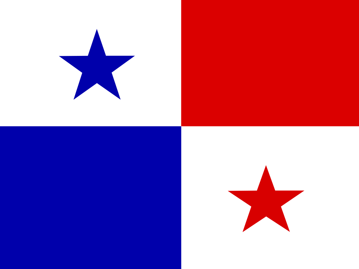
The flag of Panama
Panama's flag is divided into four quarters: white, red and blue, with a blue star in the upper-left white quarter and a red star in the lower-right white quarter.
The flag was adopted in 1904.
The colours are traditionally associated with Panama's Liberal and Conservative political parties, while the white represents peace. The stars are commonly explained as symbols of purity and honesty.
The white quarters
The two white quarters represent peace. The white areas also provide the background for Panama's two stars and give the flag its distinctive checkerboard appearance.
The blue and red quarters
The blue and red quarters are associated with Panama's two major political parties at the time the flag was created: the Conservative Party and the Liberal Party.
The design therefore reflected the political history of the newly independent republic as well as a desire for national unity.
The two stars
Panama's flag has two five-pointed stars: a blue star in the upper-left white quarter and a red star in the lower-right white quarter.
They are traditionally associated with purity and honesty, and together form one of the most recognisable features of the flag.
A short history of Panama
Panama has a long history stretching from Indigenous civilisations through Spanish colonisation, independence from Spain, union with Colombia and finally the creation of the modern Republic of Panama.
The country's strategic position became especially important after the construction of the Panama Canal, which transformed global maritime trade.
History timeline
Before European arrival — Indigenous PanamaPanama was home to numerous Indigenous peoples with their own languages, cultures, farming systems and trading networks.
1501 — European explorationRodrigo de Bastidas became one of the first Europeans known to explore the Panamanian Caribbean coast.
1502 — Columbus reaches PanamaChristopher Columbus explored parts of Panama's Caribbean coast during his fourth voyage.
1513 — Balboa reaches the PacificVasco Núñez de Balboa crossed the isthmus and became the first European known to see the Pacific Ocean from the Americas.
1519 — Panama City foundedPedro Arias Dávila founded Panama City, which became an important Spanish base on the Pacific coast.
16th–17th centuries — Spanish PanamaPanama became a key route for transporting silver and other wealth from South America to Spain, making it strategically valuable.
1671 — Old Panama destroyedEnglish privateer Henry Morgan attacked and destroyed the original Panama City. A new city was later established at the site of modern Casco Viejo.
1821 — Independence from SpainPanama declared independence from Spain and voluntarily joined the Republic of Gran Colombia.
1830s–1903 — Part of ColombiaAfter the breakup of Gran Colombia, Panama remained part of Colombia for most of the 19th century.
1880s — French canal attemptFrance began construction of a sea-level canal across the isthmus, but the project failed because of financial problems, engineering difficulties and disease.
1903 — Independence from ColombiaPanama separated from Colombia and became an independent republic, with strong support from the United States.
1904 — Panama Canal construction begins under US controlThe United States took over the canal project and began a major construction programme.
1904 — Modern flag adoptedPanama adopted the flag's present design as the national flag of the new republic.
1914 — Panama Canal opensThe Panama Canal officially opened to shipping, dramatically reducing the sea journey between the Atlantic and Pacific oceans.
1964 — Canal Zone riotsSerious unrest over sovereignty and the display of flags in the Canal Zone increased pressure for a new US-Panama relationship.
1977 — Torrijos–Carter TreatiesPanama and the United States signed treaties establishing a process for transferring control of the canal to Panama.
1980s — Noriega eraGeneral Manuel Noriega became Panama's dominant political and military figure amid growing international tensions.
1989 — US invasionThe United States invaded Panama, Noriega was removed from power and Guillermo Endara became president.
1999 — Panama takes full control of the canalOn 31 December 1999, Panama assumed full control of the Panama Canal under the treaty timetable.
2006 — Canal expansion approvedPanamanians voted in a referendum to approve a major expansion project allowing larger ships to use the canal.
2016 — Expanded canal opensThe Panama Canal expansion opened, adding a new set of locks and increasing the canal's capacity.
TodayPanama remains a major global logistics and financial centre, with the canal at the heart of its economy and international importance.
The Panama Canal
The Panama Canal is one of the world's most important engineering projects. It cuts across the isthmus and allows ships to travel between the Atlantic and Pacific without sailing around the southern tip of South America.
The canal uses a system of locks to raise and lower ships between sea level and Gatun Lake. Panama now owns and operates the canal.
Why the canal matters
The canal saves ships thousands of nautical miles on many routes and has enormous importance for global trade. It handles container ships, bulk carriers, tankers, vehicle carriers and other commercial vessels.
Because the canal depends on freshwater, drought and changing rainfall patterns can affect how many ships can pass and how much cargo they can carry.
Panama Canal expansion
The Expanded Panama Canal opened in 2016. Its larger Neopanamax locks allow substantially bigger ships to pass through the waterway.
The expansion strengthened Panama's role as a global shipping and logistics hub.
Panama's geography
Panama is a narrow isthmus with a coastline on both the Caribbean Sea and Pacific Ocean. Mountain ranges run through much of the country, while tropical forests and lowlands occupy large areas.
The country's position between two continents gives it exceptional geographical and ecological importance.
The Darién Gap
The Darién Gap is a vast area of rainforest and wetlands between Panama and Colombia. It is one of the few places where the Pan-American Highway is interrupted.
The region contains extraordinary biodiversity and is home to Indigenous communities. It is also extremely challenging terrain for travel.
Climate
Panama has a predominantly tropical climate, with a wetter Caribbean side and seasonal rainfall patterns on the Pacific side.
The dry season is generally more pronounced on the Pacific side, while parts of the Caribbean coast receive heavy rainfall for much of the year.
Panama's wildlife
Panama's tropical ecosystems support an enormous variety of wildlife, including sloths, monkeys, toucans, harpy eagles, jaguars, tapirs, sea turtles and thousands of plant species.
The country sits between North and South America, allowing wildlife from both continents to occur within its borders.
The harpy eagle
The harpy eagle is Panama's national bird and one of the world's largest and most powerful forest eagles. It lives mainly in mature tropical forests and is an important symbol of Panama's natural heritage.
Panama's national parks
Panama has extensive protected areas, including Soberanía National Park, Darién National Park and Coiba National Park.
These areas protect tropical forests, islands, coral reefs and important wildlife habitats.
Coiba National Park
Coiba National Park protects Coiba Island and surrounding marine areas on Panama's Pacific coast. The island was formerly a penal colony, which helped keep large areas relatively undisturbed.
The area is now recognised for its exceptional marine and terrestrial biodiversity and is a UNESCO World Heritage site.
Panamanian culture
Panama's culture combines Indigenous, Spanish, African, Caribbean and other international influences.
Music, dance, food and festivals reflect the country's position as a crossroads between continents and oceans.
Indigenous peoples
Panama is home to several Indigenous peoples, including the Guna, Ngäbe, Buglé, Emberá, Wounaan and Naso.
Indigenous communities maintain distinctive languages, traditions, crafts and relationships with their lands.
The Guna and the mola
The mola is a famous textile art associated particularly with Guna women. It uses layers of brightly coloured fabric and intricate cut-out designs.
Molas have become an internationally recognised symbol of Panamanian Indigenous culture.
Panamanian food
Panamanian cuisine combines Spanish, Indigenous, African and Caribbean influences. Common foods include sancocho, arroz con pollo, tamales, ceviche, patacones and seafood.
Coconut, plantain, rice, corn and fresh tropical produce are widely used.
Panama City
Panama City is the capital and largest urban centre. It combines modern skyscrapers and financial districts with the historic Casco Antiguo and the ruins of the original Panama City.
The city is also the main gateway to the canal and a major international business centre.
Casco Antiguo
Casco Antiguo, Panama City's historic district, was established after the original city was destroyed in 1671. Its colonial streets, plazas, churches and buildings form one of Panama's best-known heritage areas.
The economy
Panama has a service-based economy centred on the canal, logistics, banking, tourism, construction and commerce.
The country's geographical position and dollar-based financial system have helped make it one of the region's most internationally connected economies.
The Panamanian balboa
Panama's official currency is the balboa, but US dollar notes are used in everyday transactions. Balboa coins circulate alongside US coins and have the same value as their US equivalents.
Panama and the United States
The United States played a major role in Panama's modern history because of the construction and administration of the canal. The two countries remain close economic and political partners, although canal sovereignty was a major source of historical tension.
The flag's designer
The modern Panamanian flag is generally credited to María de la Ossa de Amador, who helped prepare the design during the country's independence movement in 1903. Manuel E. Amador Guerrero is also associated with its creation and design discussions.
Why is Panama's flag interesting?
Panama's flag is unusual because its four quarters deliberately combine political symbolism with national unity. The red and blue recall rival political parties, while the white fields represent peace and the stars express ideals associated with the new republic.
Its simple design is instantly recognisable and closely connected to Panama's birth as an independent nation.
Explore Panama on FlagAtlas
Continue exploring Panama and the world's flags with these FlagAtlas resources.