About Equatorial Guinea
Equatorial Guinea is a small country on the west coast of Central Africa. Its mainland territory borders Cameroon and Gabon, while the country also includes several islands in the Gulf of Guinea.
Malabo is the capital and is located on Bioko Island. This makes Equatorial Guinea unusual because its capital is on an island while most of its land area is on the African mainland.
CapitalMalabo
RegionCentral Africa
PopulationAbout 1.4 million
CurrencyCentral African CFA franc
Official languagesSpanish, French & Portuguese
Highest pointPico Basile
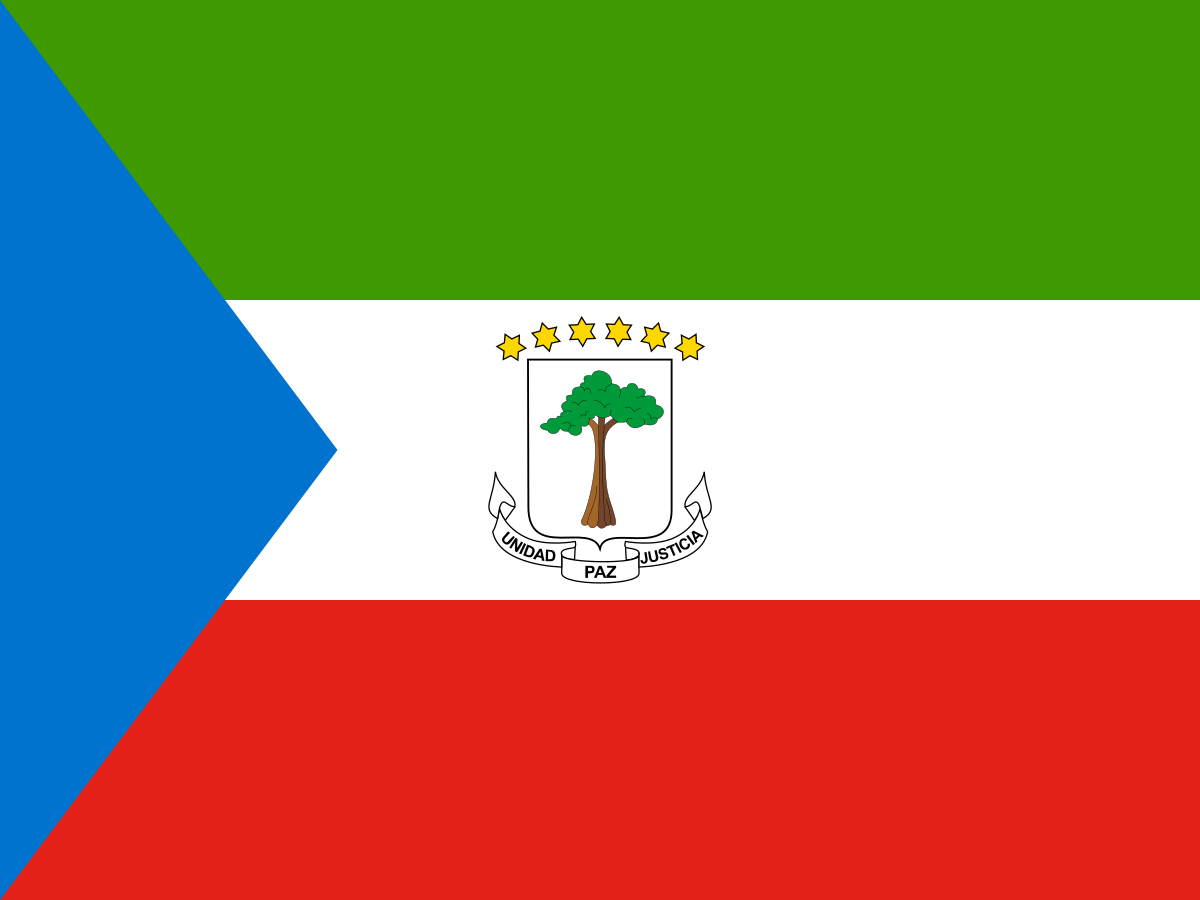
The flag of Equatorial Guinea
The flag has three horizontal bands of green, white and red, with a blue triangle at the hoist. The national coat of arms is displayed in the centre of the white band on the state flag.
The colours reflect the country's natural environment, peace and independence.
Green is associated with vegetation, white with peace, red with the struggle for independence and blue with the sea.
The blue triangle is especially appropriate for a country whose territory includes islands in the Gulf of Guinea.
What do the colours mean?
Green represents the country's forests and natural resources. White represents peace. Red symbolises the blood shed during the struggle for independence, while blue represents the sea connecting the country's mainland and islands.
The silk-cotton tree
The central emblem features a silk-cotton tree, also known as a kapok tree. It is a powerful national symbol associated with the country's history and the independence period.
The tree gives the flag a distinctive emblem connecting the modern state with its colonial and independence history.
The coat of arms
The coat of arms contains the silk-cotton tree above a scroll carrying the country's motto, Unidad, Paz, Justicia — Unity, Peace, Justice.
Six gold stars appear above the tree, representing the country's mainland territory and its five principal islands.
The six stars
The six stars above the silk-cotton tree represent the main geographical parts of Equatorial Guinea: the mainland territory and five principal islands.
The stars reinforce the idea that Equatorial Guinea is both a mainland and island country.
A short history of Equatorial Guinea
The territory of present-day Equatorial Guinea has long been home to African peoples including Fang communities on the mainland and Bubi communities on Bioko. European powers became involved from the late eighteenth century.
Spain eventually established colonial rule over the territory, which became known as Spanish Guinea. Equatorial Guinea gained independence from Spain in 1968.
Flag history timeline
Before European ruleFang, Bubi and other African communities developed societies across the mainland and islands.
1778Spain acquired rights to Bioko and nearby territories through agreements with Portugal.
19th–20th centuriesSpanish colonial administration expanded and the territory became known as Spanish Guinea.
12 October 1968Equatorial Guinea became independent from Spain.
1970sThe post-independence national symbols were altered during Francisco Macías Nguema's rule.
1979A new government restored the national symbols, including the current flag.
TodayThe green, white, red and blue flag remains the national symbol.
Spanish Guinea
Before independence, Equatorial Guinea was administered by Spain and was known as Spanish Guinea. Spanish influence remains particularly visible in the country's language and institutions.
Equatorial Guinea is unusual in Africa because Spanish remains an official language today.
Independence in 1968
Equatorial Guinea became independent from Spain on 12 October 1968. The new country adopted a flag based on green, white and red with a blue triangle and its national coat of arms.
The independence period was followed by severe political repression, and the national symbols were later modified before being restored after the change of government in 1979.
Malabo — the capital
Malabo is the capital of Equatorial Guinea and lies on the northern coast of Bioko Island. The city developed under Spanish colonial rule and contains historic buildings influenced by Spanish architecture.
The mainland city of Bata is the country's largest urban centre and an important commercial hub.
Bioko Island
Bioko is the country's most important island and contains the capital, Malabo. It is volcanic in origin and has a mountainous interior covered by tropical vegetation.
Bioko's location in the Gulf of Guinea gives the island important ecological and historical connections with the mainland.
Bata and the mainland
Bata is located on the mainland coast and is the largest city in Equatorial Guinea. It is an important centre for commerce, transport and administration.
The mainland contains most of the country's land area and extensive tropical forests.
The Gulf of Guinea
Equatorial Guinea's islands and mainland coast face the Gulf of Guinea, an important part of the Atlantic Ocean. The gulf supports fishing, shipping and marine ecosystems.
The country's island geography helps explain the blue triangle used on its national flag.
Annobón Island
Annobón is a small volcanic island located well southwest of Bioko and the mainland. Its remote position makes it one of the more distinctive parts of Equatorial Guinea's territory.
Corisco and the smaller islands
Equatorial Guinea also includes islands such as Corisco and Elobey Grande and Elobey Chico. These islands contribute to the country's maritime territory and geographical identity.
Climate
Equatorial Guinea has a generally tropical climate with high temperatures and substantial rainfall. Bioko is particularly wet in parts of the year, while the mainland has seasonal variations in rainfall.
The warm, humid conditions support dense tropical vegetation and rainforest ecosystems.
Rainforests and wildlife
Equatorial Guinea contains extensive tropical forests that support a wide range of wildlife. Forest species include forest elephants, gorillas, chimpanzees and numerous monkeys and birds.
Conservation is important because the country's forests are part of the wider Congo Basin ecosystem.
Mountains and volcanoes
Bioko is dominated by volcanic mountains. Pico Basile is the highest point in Equatorial Guinea and rises to more than 3,000 metres above sea level.
The volcanic landscape is especially visible around Bioko, where steep slopes rise from the Gulf of Guinea.
Oil and the economy
Equatorial Guinea experienced major economic change after the discovery and development of substantial oil and gas reserves in the 1990s. Petroleum exports became the dominant source of government revenue and foreign earnings.
The country has since faced the challenge of diversifying its economy and reducing dependence on hydrocarbons.
Agriculture
Agriculture remains important outside the oil sector. Traditional crops and products include cocoa, coffee, timber and food crops.
Bioko was historically known for cocoa production, while mainland forests have long supported timber industries.
Languages
Equatorial Guinea has three official languages: Spanish, French and Portuguese. Spanish is the most widely used official language and is an unusual feature of the country within Africa.
Several African languages are also spoken, including Fang and Bubi.
Fang and Bubi peoples
The Fang are the largest ethnic group and are concentrated mainly on the mainland. The Bubi are Indigenous to Bioko Island.
Other communities, including Ndowe and Annobonese people, contribute to the country's cultural diversity.
Culture and traditions
Equatorial Guinea's culture combines African traditions with Spanish colonial influence. Music, dance, oral traditions, religious celebrations and community ceremonies remain important.
The country's islands and mainland also have distinct local traditions and languages.
Religion
Christianity is the dominant religion in Equatorial Guinea, particularly Roman Catholicism, alongside Protestant traditions. Religious practice exists alongside older African cultural beliefs and customs.
Food
Equatorial Guinean food combines African ingredients and cooking traditions with influences from Spain. Common ingredients include plantains, cassava, yams, rice, fish and tropical fruits.
Coastal and island communities make extensive use of seafood, while mainland cuisine reflects Central African traditions.
Equatorial Guinea today
Equatorial Guinea is a presidential republic with a population concentrated mainly around urban areas and the more fertile parts of the mainland and Bioko.
The country continues to face the challenge of turning its natural-resource wealth into broader, sustainable development while protecting its forests and biodiversity.
Why is Equatorial Guinea's flag interesting?
The Equatorial Guinea flag is interesting because it combines a familiar African colour palette with a distinctive emblem. The silk-cotton tree, six stars and motto of Unity, Peace and Justice turn the flag into a compact representation of the country's geography and independence story.
Explore Equatorial Guinea on FlagAtlas
Continue exploring Equatorial Guinea and the world's flags.