About Eritrea
Eritrea is a country in the Horn of Africa, on the Red Sea. It borders Sudan, Ethiopia and Djibouti and has a long coastline as well as islands in the Red Sea.
Asmara is the capital and is famous for its distinctive Italian-era architecture. Eritrea became independent from Ethiopia in 1993 after a long armed struggle.
CapitalAsmara
RegionHorn of Africa
PopulationAbout 3.5 million
CurrencyNakfa
LanguagesNo single official language
Highest pointEmba Soira
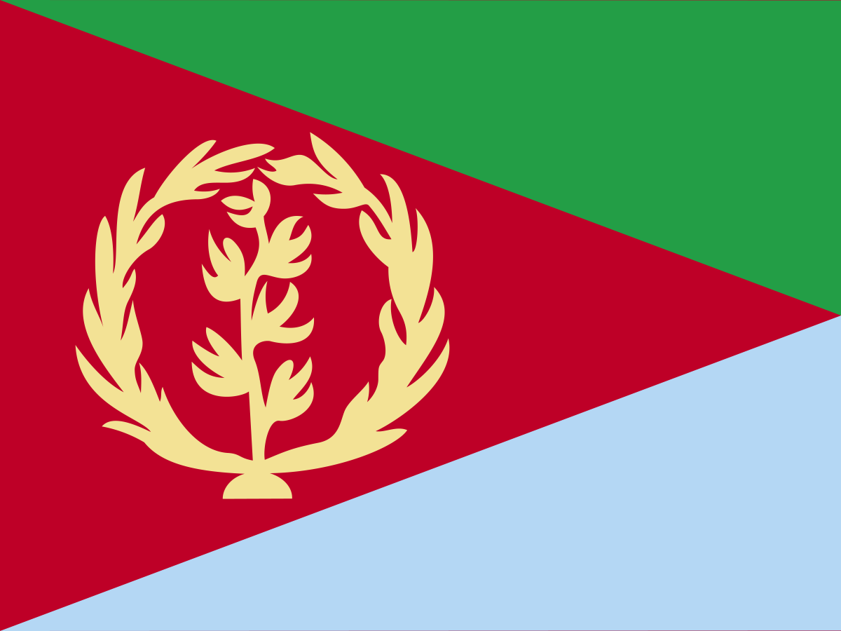
The flag of Eritrea
The Eritrean flag has a large red triangle extending from the hoist, with green above and blue below. A golden olive branch and wreath appear on the red triangle.
The flag is closely linked to Eritrea's independence movement.
Its colours and emblem draw on the earlier Eritrean Liberation Front and Eritrean People's Liberation Front symbolism and the country's long struggle for independence.
The current flag was adopted in 1995, after Eritrea became independent.
What do the colours mean?
Green represents agriculture and the country's fertile areas. Blue represents the Red Sea. Red represents the blood shed during the struggle for independence.
The colours are therefore closely tied to Eritrea's land, coastline and independence history.
The olive branch and wreath
The golden olive branch and wreath on the red triangle represent peace. The emblem is based on the symbol used by the United Nations on the Eritrean flag during the period when Eritrea was an autonomous unit within the Ethiopian federation.
It also reflects the hope for peace after the long independence struggle.
The red triangle
The large red triangle is one of the most distinctive features of the Eritrean flag. Its shape points towards the hoist and visually separates the green and blue fields.
Red is especially important because of its association with the sacrifices made during Eritrea's war for independence.
A short history of Eritrea
Eritrea has a long history connecting the Red Sea coast with the highlands of the Horn of Africa. The region was influenced by the ancient Kingdom of Aksum and later by Ottoman, Egyptian and Italian expansion.
Italy established Eritrea as a colony in the late nineteenth century. After the Second World War, Eritrea was federated with Ethiopia in 1952 and was later annexed by Ethiopia.
Flag history timeline
Ancient periodThe region formed part of the wider world of the Kingdom of Aksum and Red Sea trade.
1880s–1941 — Italian EritreaItaly established and developed Eritrea as a colony.
1952 — federation with EthiopiaThe United Nations arranged a federation between Eritrea and Ethiopia.
1962 — annexationEthiopia formally annexed Eritrea, beginning a prolonged period of armed conflict.
1991 — independence movement victoryEritrean forces took control of the territory as Ethiopia's government fell.
1993 — independenceEritrea became an independent state after a referendum.
1995 — current flagThe present national flag was adopted.
Italian Eritrea
Italy established Eritrea as a colony in the late nineteenth century. Italian rule left a particularly strong architectural legacy in Asmara, where Art Deco, Futurist and modernist buildings remain visible.
Asmara's twentieth-century architecture is now internationally recognised and forms part of a UNESCO World Heritage Site.
The struggle for independence
Eritrea's independence struggle lasted for decades. Armed movements fought Ethiopian rule after the federation was dismantled and Eritrea was annexed in 1962.
The Eritrean People's Liberation Front eventually became the dominant independence movement. Its victory in 1991 was followed by a referendum in which Eritreans overwhelmingly voted for independence.
Independence in 1993
Eritrea formally became independent on 24 May 1993, following the internationally observed referendum held in April of that year.
Independence is central to Eritrean national identity, which explains why the country's flag places such strong emphasis on sacrifice, peace and the independence struggle.
Asmara — the capital
Asmara is Eritrea's capital and largest city. It sits at high altitude on the Eritrean plateau and is known for its unusually well-preserved twentieth-century architecture.
The city was added to the UNESCO World Heritage List in 2017 for its exceptional collection of modernist buildings and urban planning.
The Red Sea coast
Eritrea has a long coastline along the Red Sea, which is represented by the blue section of the national flag. The coast includes islands, coral reefs, fishing communities and important maritime routes.
The Red Sea gives Eritrea strategic importance because it lies close to one of the world's busiest shipping corridors.
The Dahlak Archipelago
The Dahlak Archipelago consists of numerous islands in the Red Sea off Eritrea's coast. The islands are known for coral reefs, marine life and traditional fishing communities.
The archipelago forms an important part of Eritrea's maritime territory and natural heritage.
The Horn of Africa
Eritrea forms part of the Horn of Africa, alongside countries including Ethiopia, Djibouti and Somalia. Its location gives it connections with both the African interior and the Red Sea and Arabian Peninsula.
The region has been an important crossroads for trade, migration and culture for thousands of years.
Climate
Eritrea has several climate zones because of its varied elevation. The highlands around Asmara are cooler, while the eastern lowlands and Red Sea coast can be extremely hot and dry.
Rainfall is generally limited and varies considerably between regions.
Mountains and highlands
The central Eritrean highlands contain some of the country's most fertile and densely populated areas. Emba Soira is the country's highest mountain, rising to around 3,000 metres.
The highlands also help explain why Asmara has a much milder climate than the hot coastal lowlands.
Wildlife
Eritrea's habitats range from highland farms and dry savannah to desert and Red Sea marine ecosystems. Wildlife includes antelope, gazelles, monkeys, birds and a variety of reptiles.
The coastal waters and islands support coral reefs, fish and other marine species.
Agriculture
Agriculture remains important to Eritrean livelihoods. Crops include sorghum, millet, barley, wheat, maize and legumes, while livestock farming is widespread.
Rainfall variability and drought can make agricultural production challenging.
Languages and peoples
Eritrea is culturally diverse, with several major ethnic groups including Tigrinya, Tigre, Saho, Bilen, Rashaida, Kunama, Nara, Afar and Hedareb communities.
The country does not constitutionally designate a single official language. Tigrinya, Arabic and English are widely used in government and public life.
Religion and culture
Eritrea has significant Christian and Muslim populations. The Eritrean Orthodox Tewahedo Church is particularly important in the highlands, while Islam has a strong presence in many lowland and coastal communities.
Music, coffee ceremonies, food, religious festivals and traditional dress are important parts of Eritrean culture.
Eritrean food
Eritrean cuisine is closely related to the food traditions of the wider Horn of Africa. Injera, a fermented flatbread, is commonly served with stews known as tsebhi.
Dishes often include lentils, vegetables, meat and spicy sauces. Italian influence can also be seen in foods such as pasta and coffee culture.
The economy
Eritrea's economy includes agriculture, mining, fishing and services. The country has deposits of gold, copper and zinc, and mining has become an important source of export revenue.
Agriculture remains vital, but limited rainfall and the country's economic structure create significant challenges.
Eritrea today
Eritrea is a highly centralised state and has been governed by the same political movement that led the independence struggle since independence. The country has compulsory national service and has experienced substantial emigration.
Its strategic Red Sea location, historic cities and distinctive cultural heritage make Eritrea an important country in the Horn of Africa.
Why is Eritrea's flag interesting?
The Eritrea flag tells a remarkably direct story about the country. The red triangle, green and blue fields, and golden olive wreath connect the land, Red Sea and sacrifices of the independence struggle with the hope for peace after independence.
Explore Eritrea on FlagAtlas
Continue exploring Eritrea and the world's flags with these FlagAtlas resources.