About the Marshall Islands
The Marshall Islands is a Pacific island country in Micronesia, made up of two roughly parallel chains of coral atolls and islands: the Ratak Chain and the Ralik Chain. Majuro is the capital and largest population centre.
The country is famous for its low-lying atolls, strong maritime culture and its difficult twentieth-century history, including extensive US nuclear weapons testing at Bikini and Enewetak.
CapitalMajuro
RegionMicronesia / Oceania
PopulationAbout 42,000
CurrencyUS dollar
Official languagesMarshallese & English
Independence1986
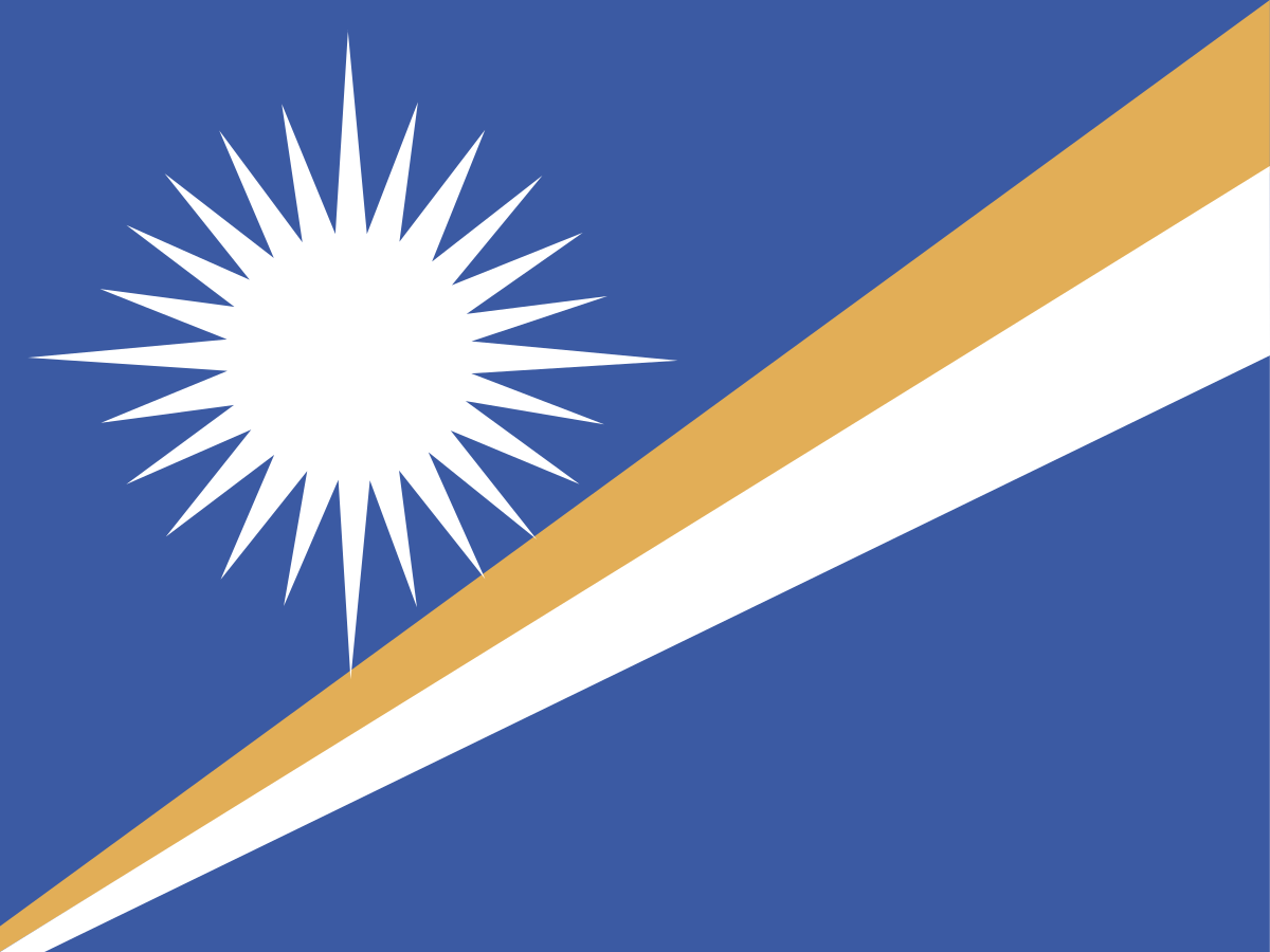
The flag of the Marshall Islands
The Marshall Islands flag has a dark blue field crossed by two diagonal bands of orange and white, with a large white star in the upper hoist.
The flag is closely tied to the geography and identity of the island nation.
The diagonal bands represent the two island chains, while the star's 24 points represent the country's municipalities.
The flag was adopted in 1979 when the Marshall Islands became self-governing in free association with the United States.
The blue field
The blue field represents the Pacific Ocean surrounding the islands.
For a country whose territory consists overwhelmingly of ocean, the colour is an especially important part of the national symbolism.
The diagonal bands
The two diagonal bands represent the two main island chains of the Marshall Islands: Ratak, meaning roughly "Sunrise", and Ralik, meaning roughly "Sunset".
The bands run from the lower hoist towards the upper fly, visually suggesting the country's long chains of islands stretching across the Pacific.
The orange band
The orange stripe represents courage and vitality and is associated with the Ralik or western chain.
Along with the white stripe, it creates the distinctive diagonal form of the flag.
The white star
The large white star has 24 points, representing the 24 municipalities of the Marshall Islands.
The four longer rays are traditionally associated with the country's four main cultural centres or major population areas, while the star as a whole evokes the islands' position in the Pacific.
A short history of the Marshall Islands
The Marshall Islands has been inhabited for centuries by Micronesian seafaring communities. Traditional navigators developed sophisticated knowledge of stars, waves, winds and currents.
European contact was followed by Spanish claims, German administration, Japanese occupation and then US control. The islands later became independent in free association with the United States.
History timeline
Ancient settlement — Micronesian voyagingMarshallese communities settled the atolls through long-distance ocean navigation and developed distinctive traditions of land, sea and community.
16th century — European contactSpanish navigators encountered the islands during the era of European exploration of the Pacific.
1788 — British namingBritish naval officers John Marshall and Thomas Gilbert travelled through the region; the islands later became known internationally as the Marshall Islands.
19th century — Missionaries and tradersChristian missionaries and foreign traders increased their presence, while traditional chiefs remained important locally.
1885 — German protectorateGermany established a protectorate over the Marshall Islands and incorporated the islands into its wider Pacific trading network.
1914 — Japanese occupationJapan took control of the islands during the First World War and later administered them under a League of Nations mandate.
1944 — US forces capture the islandsUS forces captured major Japanese-held islands during the Pacific War.
1947 — UN Trust TerritoryThe Marshall Islands became part of the Trust Territory of the Pacific Islands, administered by the United States under a United Nations trusteeship.
1946–1958 — Nuclear testingThe United States conducted 67 nuclear weapons tests in the Marshall Islands, causing lasting environmental, health and displacement consequences.
1954 — Castle BravoThe Castle Bravo thermonuclear test at Bikini Atoll became the largest US nuclear test, producing severe radioactive fallout.
1965 — Congress of MicronesiaMicronesian political institutions developed under the US-administered trust territory.
1979 — Self-governmentThe Marshall Islands adopted a constitution and became a self-governing republic.
1983 — Compact of Free Association signedThe Marshall Islands and United States agreed a Compact of Free Association establishing a close political and economic relationship.
1986 — Independence in free associationThe Compact entered into force and the Marshall Islands became independent while maintaining free association with the United States.
1991 — UN membershipThe Marshall Islands joined the United Nations as a sovereign member state.
1990 — Bikini Atoll listed by UNESCOBikini Atoll was later recognised as a World Heritage Site because of its nuclear testing history and cultural significance.
21st century — Climate concernsSea-level rise, coastal erosion and saltwater intrusion have become major national concerns because the islands are extremely low-lying.
TodayThe Marshall Islands remains a sovereign Pacific republic in free association with the United States, with a strong focus on climate diplomacy and ocean protection.
Traditional Marshallese navigation
Marshallese navigators developed highly sophisticated ways of crossing the Pacific without modern instruments. They used stars, ocean swells, winds, currents and observations of birds and marine life.
Traditional navigation remains an important part of cultural heritage and demonstrates the depth of knowledge developed by Pacific island societies.
The atolls
An atoll is a ring-shaped coral reef surrounding a lagoon. The Marshall Islands consists almost entirely of atolls and small coral islands.
Majuro, Kwajalein, Bikini and Enewetak are among the best-known atolls.
Ratak and Ralik
The Marshall Islands is divided geographically into two main island chains: the Ratak Chain in the east and the Ralik Chain in the west.
The names are traditionally translated as "Sunrise" and "Sunset", reflecting their positions relative to one another.
Bikini Atoll
Bikini Atoll became internationally known because the United States conducted 23 nuclear tests there between 1946 and 1958.
The testing displaced Bikini's inhabitants and left a lasting legacy of radiation, environmental damage and unresolved compensation issues.
Castle Bravo
On 1 March 1954, the United States detonated Castle Bravo at Bikini Atoll. It was the largest nuclear test ever carried out by the United States.
The explosion was much more powerful than expected and produced radioactive fallout that affected nearby atolls and the Japanese fishing vessel Daigo Fukuryū Maru.
Enewetak Atoll
Enewetak Atoll was another major US nuclear testing site. The United States carried out numerous tests there during the Cold War.
A large concrete containment structure, often called the Runit Dome, holds radioactive material and remains a visible reminder of the testing era.
The Compact of Free Association
The Compact of Free Association governs the close relationship between the Marshall Islands and the United States.
Under the compact, the Marshall Islands is a sovereign country, while the United States provides defence and certain forms of economic assistance. Marshallese citizens also have special rights to live and work in the United States.
Majuro
Majuro is the capital and principal urban centre. The atoll is a narrow strip of land surrounding a large lagoon.
Government, commerce, transport and much of the country's population are concentrated in the Majuro area.
Kwajalein Atoll
Kwajalein Atoll contains one of the world's largest lagoons and hosts important US military and missile-testing facilities.
The atoll has been strategically significant since the Second World War and remains central to the US-Marshall Islands relationship.
Marshall Islands culture
Marshallese culture is closely connected to the ocean, family, land rights, navigation and community.
Traditional weaving, canoe building, storytelling, dance and song remain important expressions of cultural identity.
Marshallese language
Marshallese is an Austronesian language with two major dialect groups corresponding broadly to the eastern and western island chains.
English is also an official language and is widely used in government and education.
Marshallese food
Traditional food relies on locally available fish, coconut, breadfruit, pandanus and taro.
Imported foods are also common today because the atolls have limited agricultural land and depend heavily on outside supplies.
Marshall Islands climate
The Marshall Islands has a tropical marine climate with warm temperatures throughout the year.
Rainfall varies between the atolls, while drought, storms and changing ocean conditions can have major effects on food and water supplies.
Climate change and sea-level rise
The Marshall Islands is among the countries most vulnerable to sea-level rise. Most land sits only a few metres above sea level.
Saltwater intrusion, coastal flooding and erosion threaten homes, infrastructure, freshwater and food security. The country has therefore become a prominent voice in international climate negotiations.
Marine life
The surrounding Pacific waters support coral reefs, sharks, tuna, turtles, seabirds and many other marine species.
Fishing is important for food and livelihoods, while the health of the ocean is essential to the country's long-term future.
The economy
The Marshall Islands has a small economy supported by government services, fisheries, foreign assistance, the Compact of Free Association and maritime services.
The country's limited land and distance from major markets make economic development challenging.
Shipping and the maritime sector
The Marshall Islands is well known internationally for its ship registry. The Marshall Islands Registry is one of the world's major open registries for commercial vessels.
Maritime services therefore provide an important source of international economic activity despite the country's tiny land area.
Nuclear testing legacy
The nuclear testing programme remains one of the most important parts of modern Marshallese history. Between 1946 and 1958, the United States conducted 67 nuclear tests in the islands.
The programme caused displacement, contamination and long-term health and environmental concerns. Bikini Atoll's history is now recognised internationally through UNESCO World Heritage status.
The Marshall Islands today
Modern Marshall Islands is a sovereign Pacific republic with strong historical and economic links to the United States.
Its priorities include climate adaptation, protecting marine resources, addressing the legacy of nuclear testing and preserving Marshallese culture and traditional knowledge.
Why is the Marshall Islands flag interesting?
The Marshall Islands flag is unusual because it tells a story through its geometry: the diagonal bands represent the country's two island chains and the 24-point star represents its municipalities.
Few national flags communicate a country's geography so directly.
Explore the Marshall Islands on FlagAtlas
Continue exploring the Marshall Islands and the world's flags with these FlagAtlas resources.